-
Drunk Driving is OK in Canada
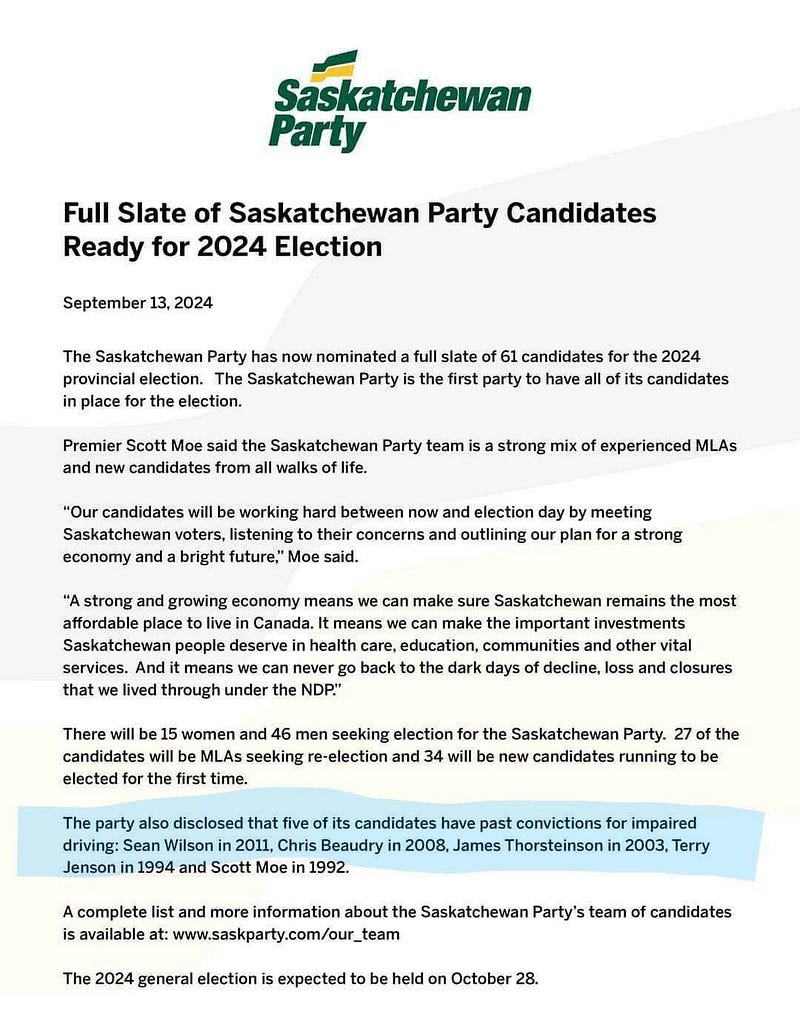
Press release from the Saskatchewan Party on September 13, 2024
Often I find myself writing about transit and thinking that many lives would not have been lost were we to have more publicly funded transit options. However, despite all of that, we have governments that don’t ever equate the use of transit and the reduction of vehicular alcohol abuse.
Earlier this month, The Saskatchewan Party released details about its slate of candidates ahead of the election writ being dropped. What was interesting was a line stating that there are five candidates who have past drunk driving charges.
Scott Moe, both current leader of the Saskatchewan Party and Premier of Saskatchewan, is also included in this list of having an impaired driving charge in 1992.
However, what is not mentioned here is that he has had two other incidents including a 1994 charge of a hit-and-run and a 1997 collision that took the life of a mother of two sons.
In the 1994 incident, Scott Moe never received a breathalyzer test but did admit that he had consumed alcohol earlier in the day. However, there is a contradiction in all of this because this is what the police charge stating:
…control of a motor vehicle that was involved in an accident with a vehicle at the Shellbrook Co-op with intent to escape civil or criminal liability, fail to stop his vehicle and give his name and address…
With Moe clarifying in an interview when he was confronted over it:
I exchanged information with the owner of the other vehicle and I called in the accident to the police.
Of course, since he apparently only called in the accident to police, there would be no evidence of him being under the influence at the time. We will just have to take him at his word that in 1997 when he killed 39-year old Joanne Bolog and injured her 18-year old son.
No alcohol was cited here, but he was charged with driving without “due care” and “failing to come to a complete stop”.
Especially rich considering that in 2019, the Humboldt Broncos junior hockey team had sixteen players killed when their bus was hit by a truck in a much similar fashion. The driver of the truck, who was just a permanent resident at the time, is now facing deportation.
Scott Moe commented on the tragedy:
“Nobody sets out one morning with any intent of being in a car accident of any type […] [to] some degree I feel for Mr. Sidhu and his family.”
Moe is just lucky that he has a certain degree of privilege that lets him get away with his past behaviour.
I could comment on other reasons for why Scott Moe (and his Saskatchewan Party) are a danger to others, but it doesn’t really matter what happens before you enter public life because it won’t matter when you are in office as Premier of a province anyhow.
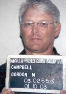
Then-Premier of British Columbia, Gordon Campbell
In January 2003, while leaving friend and Vancouver-area broadcaster Fred Latremouille’s Hawaiian home, Premier Gordon Campbell was arrested and pled no contest to driving under the influence of alcohol.
In Hawaii, it was merely a misdemeanour and not a criminal offence such as the case is in Canada, so he was fined US$913 and sent on his merry way under the condition he be checked for alcoholism and participate in a substance abuse program.
Calls for his resignation were made from groups such as MADD, but he managed to survive another seven years in office only resigning in March 2011 after being bogged down by a poorly implemented sales tax.
Drunk driving is OK because these two idiots never faced the music for it.
-
Goodbye cohost; don't let perfect get in the way of good
This was mirrored from cohost after being posted as my final piece there before it went into “read-only” mode.
This is my last long-form post on cohost and I figure I’d give you my thoughts before I go.
I’ve been on some form of social media for better or for worse since December 2000. To put into context where I was at in life back then, I was 16-years old and was still in secondary school. I was not an adult but found myself amongst many people who were often twice my age. These were people who themselves before then didn’t have Internet access in the same form I did at my age, and yet here we all were congregating together.
This of course was the Something Awful forums and while not social media explicitly (really “ur-social media”), it had all of the functions of social media baked within.
At the same time, I also joined LiveJournal, which is why I found cohost rather liberating. While the stories I could talk about from the Something Awful forums could be relatable to someone on cohost, because of its primitive nature, they would not compare to what I saw on LJ. However, both shaped the Western Internet good and bad and it’s why I have always had hesitation to comment on the affairs of this website.
However, since this website is about to cease to be anything but a time capsule in just a few weeks, that hesitation is no longer there as the audience is beginning to disperse.
One of the things that made cohost interesting is that it was rather insular. This is not a negative, but things didn’t escape the confines of this website often. Memes such as Ryan Reynolds’ becoming carbon and “Love Honk” did escape this website, but CSS crimes while cool did not spread around because they simply could not.
Somehow search indexes loved cohost URLs and it led to the local transit agency becoming aware of my posts, but they didn’t drive people to come here and participate.
Something Awful for example had a lot of content leak out to the point where it was basically freebooted for someone else’s profit. All your base are belong to us is a perfect example as after a forum member made a song to commemorate the meme, someone lifted it to create a video and it then spread like wildfire.
This wasn’t a bad thing for the forums ultimately as it led to more people joining the place, but the song’s creator, JRR never really saw a cent for it and sadly passed away in 2011 without people outside of the forums noticing.
LiveJournal was a different beast. It is more of an analogue to cohost than SA and often when describing this website to people, I tell them it’s like what Tumblr and LiveJournal birthing a child would be.
However, LJ never really had memes like AYBABTU, but it did however birth a toxic culture that fortunately never saw the light of day on this website. I won’t elaborate on what this culture evolved into, but much of the ills of the Western Internet can be focused on one particular account that went out of its way to document all of the misgivings individuals users engaged in.
These sites have aged in weird ways and ended up as neighbourhoods I could not navigate anymore.
And that is why I am sad to see cohost go the way it did. Its demise was never surprising as launching a social media website in the year 2022 is risky, but it still saddens me as it was my home on the Internet. I was one of the original test users with a two-digit user ID and was excited to see this go somewhere especially in light of my departing Twitter.
cohost was never perfect and was never destined to be–it didn’t need to be. I have long-practiced the philosophy of not letting perfect get in the way of good or as I put it, looking for satisfaction. I could go on and on about the flaws of this website, but it’s not important to me as this website actually tried a new approach to things.
I think that for many of you, you will never understand this mindset I hold. It’s easy to lash out at the site’s creators for doing things in a way you think is wrong, for not having the right policies, for not adopting the right features, and so on, but it’s another to go and look at them pragmatically–I can point out so many shortcomings I witnessed on part of the ASSC here, but I will not because it’s not pragmatic.
They tried. They put the work in. They listened. They worked what they could. They taxed themselves. Even in shutting down this place, they told us what is up. They told us how much it cost to run this place. Many of you were right, but did you ever try yourself? How did you come to that conclusion?
I’ve run a startup myself and I never once vented out what I thought was wrong.
Some of the worst behaviour I ever saw on the Internet has been on this website and yet somehow I still wanted these individuals around because I wanted them to see them succeed because their success was cohost’s success.
This website drove four people to burn out–Tumblr somehow has 2,500 employees I will point out here. Workload and user behaviour definitely played its part in their role in how this website succumbed, but I don’t see it as a failure because they pointed out a huge problem with the Internet: capitalism reigns supreme.
We don’t have good online communities anymore that are accessible. cohost does have accessibility issues I must point out, but its barrier to entry is significantly lower considering it was never really riddled with algorithms such as what is seen on Facebook. The capitalism machine has turned that social media website into a place where some countries cannot share news, people in their 60s respond to AI-generated posts and say it is truth, and selling a video card on the website often requires you to know where the closest CCTV camera is pointed at.
cohost never devolved into a place to post shrimp Jesus and I’d argue it hasn’t devolved at all. It pointed out the problems with running a service on the Internet. In a better timeline, this website would have thrived and many would clamour to have the coolest user names, the coolest CSS crimes, and the best love honk remixes.
cohost was a success because it did cool shit™ and it did shit no other website has ever done.
When this website ceases to permit new posts and is then confined to the Internet Archives, it should be looked at fondly. I want this post to be in the IA and I want people to hate what I have to say. I’ve been on the Internet long enough to not feel bothered by what I am posting here and the responses that it delivers.
When you find your new home on the Internet, remember this: don’t let perfect get in the way of good.
Make whatever your new home is your home. Learn to cultivate what you see and filter out what you do not want. Do not expect others to make their home on the Internet inviting to you, but you should also make good neighbours with those whose gardens have similar flowers as you.
You may not always like everything about your neighbours, but they’ll be there for you when you need your garden appropriately watered while you are not there.
-
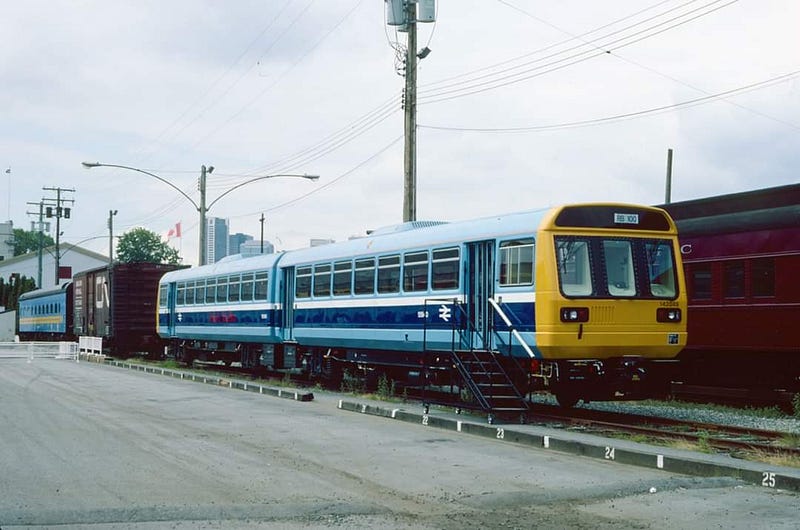
British Rail and its attempt to sell Vancouver on a Railbus
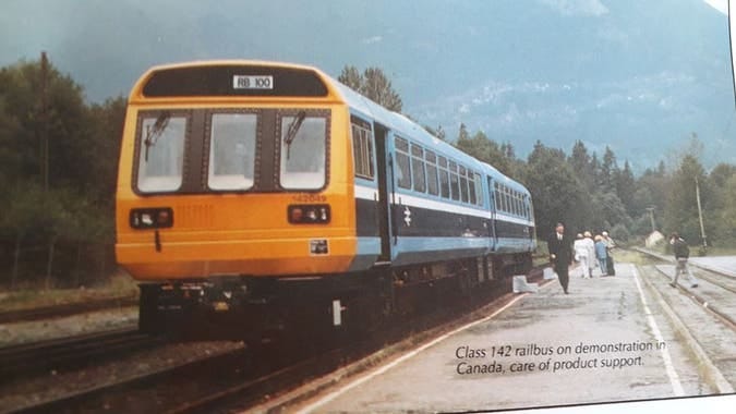
Promotional image showing a Class 142 railbus somewhere in the Fraser Valley (British Rail)
The theme of Expo 86 was transportation and many, many countries took advantage of the show to demonstrate their developments in this field. Of course, the star of the show was Canada’s SkyTrain, but Japan showed its maglev train, America its cars, and the United Kingdom showed its conventional rail.
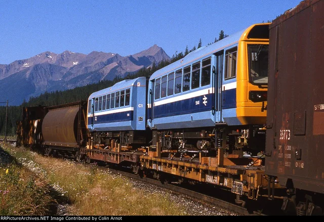
Said railbus being transported to Vancouver (Colin Arnot/RRPicturesArchives.NET)
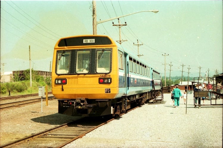
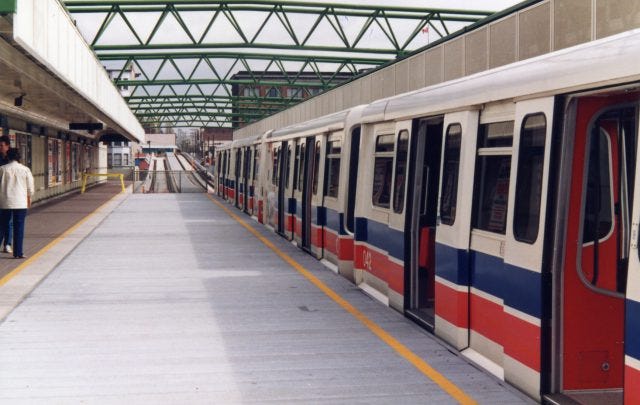
British Rail, the then government corporation behind operation and development of rail transportation in the United Kingdom decided to send one of its Class 142 train sets (aka “Pacer”) diesel trains (dubbed as “railbus”) to tour Metro Vancouver.
They regularly ran service from a temporary station in Abbotsford to New Westminster during the summer months of 1986 along the railway once referred to as the Fraser Valley Line during the BC Electric Railway days.
Railbus parked at the railyards in Strathcona (City of Vancouver Archives)
It did make an appearance near the Expo grounds at Pacific Central and was given a largely lukewarm reception by locals and government officials. The common critique of the train was the one shared by those back in the UK: it was an uncomfortable ride.
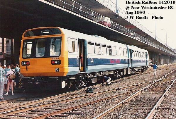
Railbus parked in New Westminster (J.W. Booth)
The reasons behind the uncomfortable ride are known: unlike most trains, this was based on a bus made by British Leyland. A rail chassis was fixed to the bus body and then some slight modifications were made to the cab to make it “rail-ready”. Unlike a typical train, the wheels were fixed in place which made them noisy. To add to this, there were only two axels per car unlike the typical four you’d see on other trains including all of the ones used by SkyTrain today, which resulted in a rougher ride.
Railbus parked somewhere in the Fraser Valley (City of Vancouver Archives)
After the summer, the train set was sent back to the UK where it operated on various different services until all Pacers were retired at the end of 2020.
-
250 KM north of Vancouver
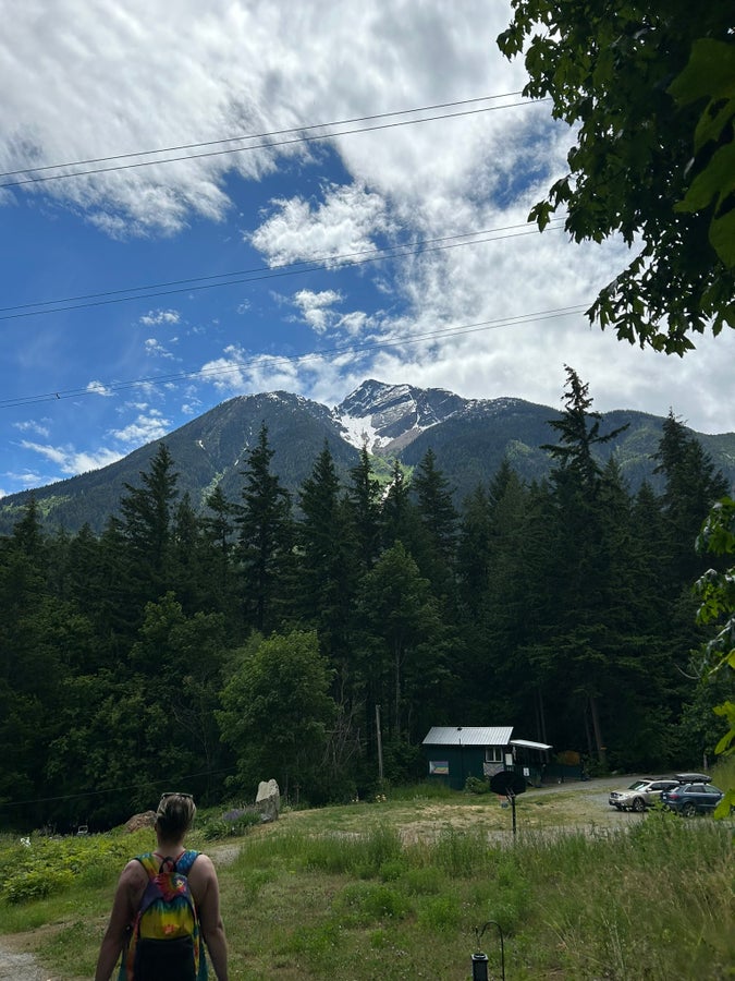
Waking up and seeing this mountain each morning while camping was just excellent.
(Taken just north of Pemberton, British Columbia)
-
The History of New Westminster Station
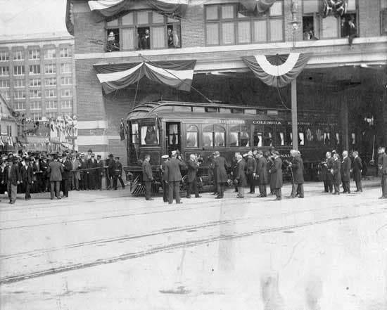
BC Electric train at New Westminster Station during the Duke of Connaught visit (City of New Westminster)
New Westminster Station today
For those who use New Westminster Station on the regular, it’s a place you either pass through, you get off to see a movie, or you catch a bus from to go up the steep hills of the city is named for. However, it has a long history of being a terminus going back to the early 20th Century.
The original station building was located adjacent to the present-day station and is now a thrift store and office. It was opened in 1891 and sat directly next to the Canadian Pacific Railway’s station.
Interurban as seen from the entrance of New Westminster Station (City of Vancouver Archives)
It was a terminus for the Burnaby Lake and Central Park BC Electric Railway (BCER) interurban lines plus provided through service for the Vancouver to Chilliwack service as well. Add on top the street cars that littered New Westminster and a connection to Richmond (Lulu Island) and also to Vancouver via the Marpole line, you find yourself with a major hub for railway services in the region.
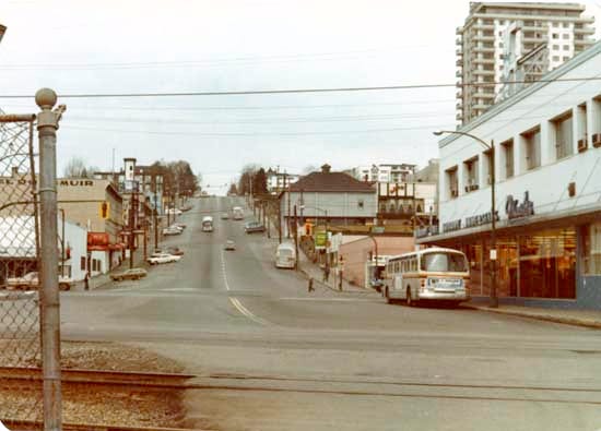
New Westminster Station’s current location as seen in the early 1980s (City of New Westminster)
With the dissolution of passenger service provided by the BCER, New Westminster being a transportation hub in what was then Greater Vancouver came to an end. It became an area dominated by the car especially after the City of New Westminster opted to build a giant parkade on its waterfront in order to “revitalise” the area.
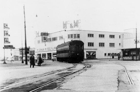
New Westminster Station as seen in 1986 (City of Vancouver Archives)
In 1985, New Westminster returned to being a transportation focal point with the opening of SkyTrain service and once again it became a terminus station. To facilitate it being a terminus station, half of the tracks were covered over with a temporary platform. This was because there was a planned extension to another station in the downtown area and then off to Surrey.
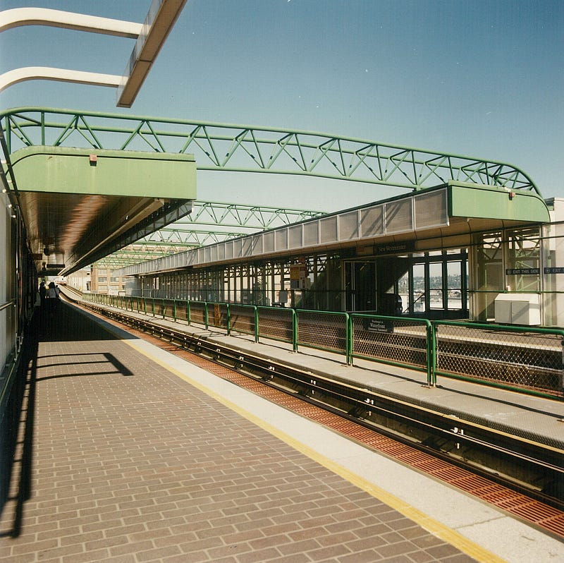
New Westminster Station as seen in the 1990s
This station became important to New Westminster’s efforts to revitalise its downtown core and in the 2000s, it became a focal point for densification. The former grounds of a car dealership, a parking lot, and a retail complex were all to be used as part of turning the station into a hub for residences and shopping.
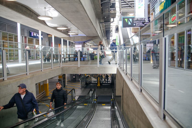
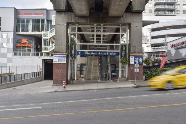
New Westminster Station is now part of a shopping centre
Today, New Westminster station is not only a hub for connections elsewhere in the city and beyond, but you can go there to get your groceries, eat a meal, and watch a movie. It even acts as an intermodal as a brief walk can take you to a ferry which connects downtown New Westminster with Queensborough.
Perhaps in the future it will be a connection to Vancouver via the old Marpole line?
This was originally posted to cohost.org/VancouverTransit.